Harris Hill
Harris Hill is located in south central New York State just south of Big Flats and west of Elmira. The site is approximately 750 feet in altitude over the valley which itself lies at aprox 780 ft ASL. The site faces NW favoring slightly a WNW wind. The launch is a steep slope launch, as are many in the area. The HG launch is also located very near Harris Hill Glider Port (sail planes), which is also the location of the National Soaring Museum. Schwietzer Aircraft Company, one time maker of the well known sail planes is located in the valley to the north of Harris Hill.
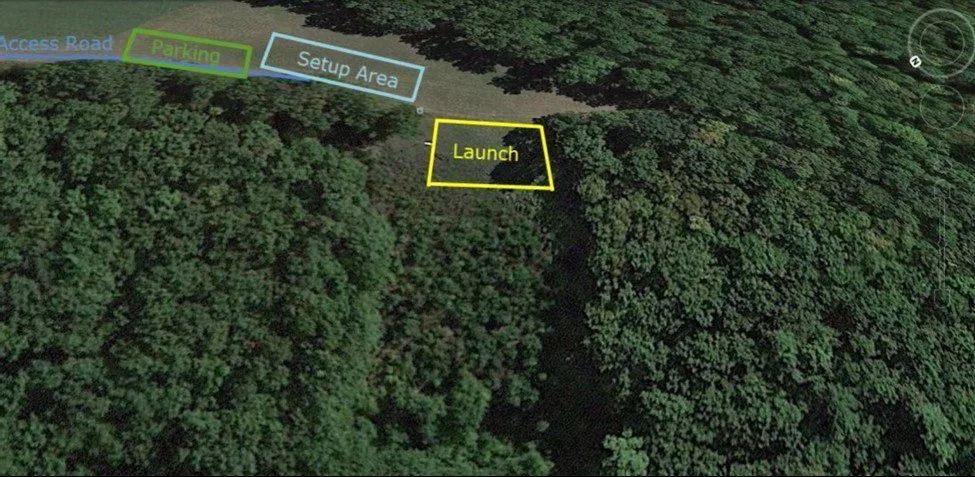
Harris Hill Launch
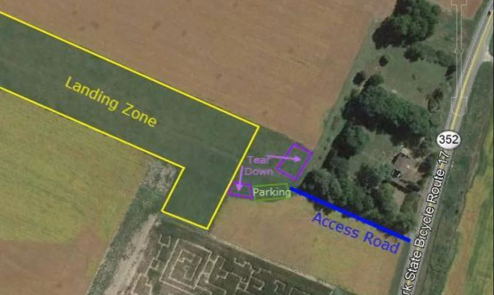
Harris Hill Landing Zone
Updated 11/10/2026
HARRIS HILL (RHODES RIDGE) SITE GUIDE
Overview
Type: northwest facing, eastern mountain site, near Elmira, NY, uniquely located in Elmira Class D airspace
Geography: three-mile wooded ridge with a flat Chemung River valley in front of it
History: opened 1974 by FSF, flown continuously; sharing ridge with glider port where sailplanes first flown in US
Launch
GPS Coordinates: 42.112324, -76.915889
Elevation: 1650’ MSL (750 AGL)
Glide to LZ: 4:1
Minimum Ratings & Skills: H2/P2 (new H2/P2 w/ supervision) and FL
Best Wind direction/speed: NW (315o), 5-15 mph (rotor/sink likely beyond 290⁰-330⁰ range). Can be safely flown in smooth straight-in (300o-325⁰) wind to 15-20 mph with gusts to 25 mph, smooth 30 degrees crossed wind to 10 mph.
Description: well maintained, moderately sloped, fairly open, grassy slot on west side of wooded ridge
Hazards: in a west cross, expect turbulence due to rotor from Steege Hill upwind of launch; in soarable conditions, expect increased ridge traffic from fast-moving sailplanes with whom we share the ELM-designated Soaring Area; expect general aviation traffic due to proximity of Elmira-Corning Regional airport (ELM)
Access: gated dirt and gravel right-of-way off Harris Hill Road, passable by 2WD vehicles with good ground clearance but impassable when snow creates drifts behind crest of ridge line
Parking: the 5-acre field behind launch can accommodate many vehicles
Setup: the 5-acre field behind launch can accommodate many gliders
Control: excluding the privately owned access path, property is Club owned, launch is maintained by FSF, and use is regulated by FSF; Elmira Tower retains authority over flight operations in its control zone
Landing Zone
GPS Coordinates: 42.117743, -76.923353
Description: at distance ½ mile from launch, primary LZ is flat but narrow rectangular field used as a bailout for sailplanes flying harris Hill and consequently kept in good condition; it is bordered by Rt 352 at its west end, a tree-lined creek at its east end , and flanked by fields of crops on both sides
Hazards: in a west cross, expect turbulence due to rotor from Steege Hill opposite the west end of the LZ; narrowness of field and tall crops may restrict landing direction and favor using a nearby fallow field as an alternate; powerline along Rt 352 west of landing field, teardown and parking areas
Access: 100-yard dirt/gravel path from Rt 352 into sailplane bailout field, suitable for 2WD vehicles
Parking: at the extreme western end of the bailout field, accommodating four to six vehicles
Teardown: upon landing, immediately move glider to area at the extreme western end of the bailout field, next to parking.
Control: property is privately owned, LZ is maintained by the county for the benefit of Harris Hill Soaring Society, Club use is regulated by FSF, subject to terms & conditions of landowner agreement.
Protocol
Visiting pilots/new members must be accompanied by Board-designated LOCAL member for access, site briefing, and flight activity. Convene in teardown area of LZ off Route 352, plant a windsock at upwind end of landing field, transfer equipment (carpool as convenient to minimize traffic). Lead vehicle opens
gate to access right-of-way, positions gate to side. Place wind indicators in the slot. Prior to the commencement of any flying, telephone Elmira Tower (607) 739-1971 to activate hang gliding at Harris Hill. At the conclusion of the day’s flying, telephone Elmira Tower to report the cessation of hang gliding activity. Last vehicle retrieved ensures access gate is closed and chain-latched.
XC Options
XC potential is very good and the site is productive; pilots leaving Harris Hill downwind must overfly the city of Elmira. Beyond which landing fields are abundant; reaching Chemung, route options are heading south down the Susquehanna River valley or east up the valley toward Binghamton; waypoints or LZs for
landing out have not been established.
Restrictions
Gliders must remain clear of parts of Elmira Class D airspace not included in Harris Hill Soaring Area, defined as that part Class D airspace south of a line from Wells Lane bridge through fairgrounds racetrack to east edge of control zone and through the intersection of Rt 352 and Winters Rd to west edge of control
zone. Elmira Tower may restrict flight operations due to unusual airport traffic. Whenever there is any sailplane activity, remain clear of glider port traffic pattern and avoid flying in front of runway ends, maintaining a minimum crossing/overflight altitude of 1000’ AGL.
SITE RULES 12/15/2021
APPLICABILITY
These Rules apply to all Club-regulated flying sites unless stipulated otherwise.
Mountain Sites: Harris Hill (WNW-NW), Indian Cliffs (N-NE), Katydid (SW-W)
These Rules may at any time and without notice be superseded at the discretion and direction of the landowner and may be amended by a vote of the Board of Directors.
PREREQUISITES
Memberships:
You must be a member in good standing of Free Spirit Flight Hang Gliding Club, Inc. (Club) and a current member of the United States Hang Gliding and Paragliding Association (USHPA).
Ratings:
To fly a hang glider or paraglider at any mountain sites, you must be at minimum a supervised USHPA-rated Novice or Class 2, respectively. To fly a hang glider or paraglider at any training sites, you must be at minimum a supervised USHPA-rated Beginner or Class 1, respectively. Tandem flying requires appropriate USHPA Tandem Ratings for the pilot and USHPA membership for the passenger. Visiting instructors must be USHPA Certified Instructors and have contacted the Club before bringing students.
EQUIPMENT
Glider and harness must be airworthy, subject to inspection by an Instructor, Observer, or Safety Director. An emergency parachute and helmet must be worn; however, the requirement for a parachute may be waived by an instructor or Observer for a non-soaring training flight. The use of powered hang gliders, powered paragliders, and paragliding mini-wings are not permitted.
FLIGHT
Occupancy:
Pilots must be accompanied by a Club-designated LOCAL member unless prior arrangements have been made with a director. It is strongly recommended that no pilot fly alone; however, Club members in good standing may use their own judgment and fly alone, provided they have at least an Intermediate (H3, P3) rating and a person able to call for help is present.
Areas:
Identify the current landing zone since designated landing areas are subject to seasonal change. Identify applicable Airport Control Zones, Restricted Areas, and No-fly Areas.
Access:
Obtain permission from the landowner to enter their land and use the site. Even if permitted to drive in, do not proceed further if tires begin to spin.
Launching/Landing:
Observe mitigation measures proscribed by site-specific risk assessment plan. Before initiating and after completing flight activities at Harris Hill and Indian Cliffs - sites within “Controlled D” airspace - contact the Control Tower at the Elmira-Corning Regional Airport (607-739-1971).
PROHIBITIONS
Do not go to launch without explicit permission. Use of ATV’s and dirt bikes are prohibited. Do not leave trash, litter, or waste products. Fires are forbidden. Show no disrespect to landowners or their property. There is no hunting allowed on Harris Hill.
Safety
Dogs must be on a leash and are not permitted during launch and landing operations. Make sure that any spectators, guests, and any other non-flying persons (including pets on leash!) stay clear of launch and landing areas and do not get in the way. Make them aware of any dangers to themselves and pilots
Emergency Plan
In the event of an emergency call 911 and provide GPS or street location nearest.
Access to launch by emergency responders is access road.
Nearest town is Big Flats, NY.
For more information, site introductions and verifying that this site is open contact the Site Coordinator:
TBD
315-tbd-tbdt
-
* RAF Pilot conducting Site Briefing should point out many of the critical elements noted in the Bristol Site Guide including the issues below.
* Verify RAF and USHPA membership and ratings required.
Launch Details
Wind window
Ideal wind directions
Maximum/minimum winds
Launch setup and launch tips.
Weather/Wind/Environmental Issues
Flight Hazards & Local Gotchas
Rotor zones
Tree lines
Power lines
Slope shape issues
Known turbulence
Landing Zones
Primary LZ
Alternate LZs
Address any pilot questions or concerns...
Harris Hill Landing Zone - click for directions on Google Maps